A dense agricultural mosaic covers Taiwan along the Zhuoshui River
Satellite observations reveal how tight land boundaries and steep terrain compel farmers to cultivate thousands of micro-plots across the floodplains of the western coast.
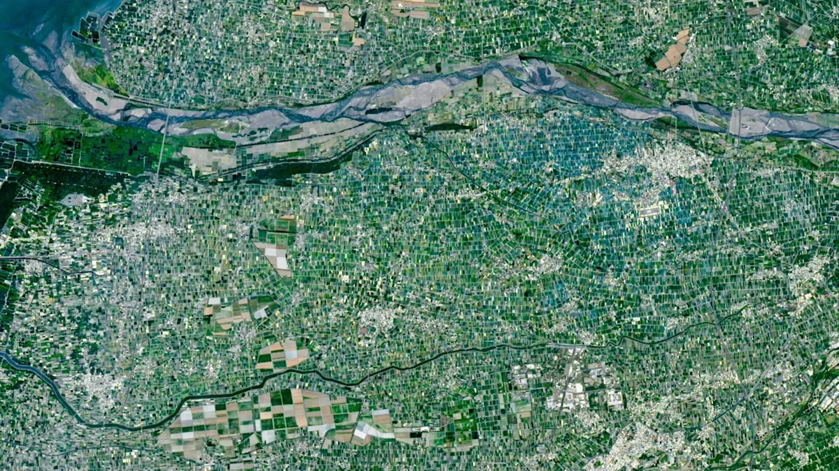
Why does western Taiwan look like a miniature patchwork?
Farmland in southwestern Taiwan resembles an intricate geometric quilt when viewed from hundreds of kilometres above the surface of the Earth. Tens of thousands of tiny, distinct rectangular plots press directly against one another across the flat terrain, showing abrupt colour shifts between bright turquoise, pale tan, and deep green over spans of just a few dozen metres. Unlike the vast, uniform expanses of industrial monoculture that characterize many agricultural river valleys around the world, this landscape is divided into hyper-concentrated micro-farms that change character with nearly every parcel boundary.
The visual arrangement reflects severe physical and legal constraints on food production. Taiwan covers approximately 36,000 square kilometres, an area roughly equivalent in geographical size to the state of Maryland.12 Yet it sustains a population of approximately 23 million people, which is nearly four times the population of Maryland.12 Because rugged mountain ranges and dense rainforests dominate much of the island, only about one-quarter of the total land area is arable.21 Food producers must therefore generate substantial agricultural yields within a narrow coastal corridor of flat ground.
The resulting land allocation leaves an unusually small slice of cultivated ground for every resident. Across the island, arable farmland averages approximately 0.03 hectares per citizen, which translates to roughly 300 square metres, or about 3,200 square feet.21 That amount of cultivation space is roughly two-thirds the size of a standard basketball court.1 By comparison, an average citizen in the United Kingdom has access to roughly twice as much arable farmland, and an average resident in the United States has access to about 10 times as much.21
Under these conditions, agricultural survival relies on a chain of physical and logistical factors. Water and silt flow down from the central highlands through major drainage arteries, depositing fertile sediment along the coastal plain. Coastal farmers establish tightly bounded parcels defined by access to irrigation channels and perimeter roadways. To maximize return on tiny family allotments, growers choose diverse, high-value specialty crops rather than single-crop field plantings. When observed from orbit, this dense spatial strategy creates a fine-grained mosaic of alternating crops, protective canopies, and specialized facilities.
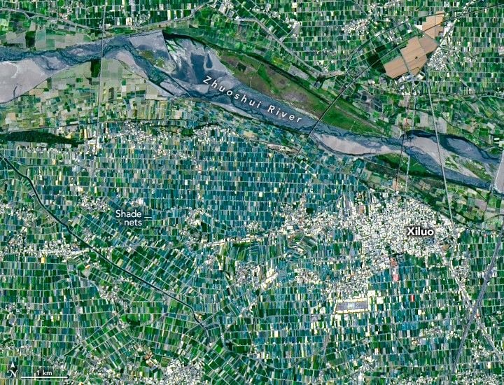
How do river floodplains support such intensive cultivation?
Yunlin County serves as the primary agricultural powerhouse of Taiwan, producing the majority of the food on the island.12 The county sits along the central section of the Chianan Plain, a long, flat coastal strip that borders the western shore of the island.12 Natural geography provides ideal agricultural conditions across the county, specifically the fertile floodplains and irrigation networks supplied by the Beigang River and the Zhuoshui River, the largest river on the island.21
Cultivation across Yunlin County is so diversified that neighbours frequently grow completely different crops on adjacent plots separated by narrow tracks. The region is known for yielding rice, sweet potatoes, peanuts, corn, sugarcane, garlic, scallions, coffee, fruit, and leafy green vegetables.21 In addition to plant crops, these agricultural properties raise livestock, including cattle, chickens, and millions of pigs, which represents the highest swine population of any county in Taiwan.21 According to the Ministry of Agriculture in Taiwan, the agricultural industry of the island generates approximately $18 billion in goods each year.2
The modest scale of these operations is reinforced by both history and inheritance laws. Longstanding statutory limits cap the maximum acreage an individual citizen can legally own.12 Over successive generations, family estates have been repeatedly subdivided among heirs, carving properties into increasingly compact parcels.21 The average farm across Taiwan measures less than one hectare, or under 10,000 square metres, which is smaller than 100,000 square feet.21 By comparison, the average farm in the United Kingdom measures 87 hectares, and the average commercial farm in the United States covers 187 hectares, making typical Taiwanese holdings roughly 90 times smaller than their American counterparts.21
What explains the unusual colour patterns seen from orbit?
Observations recorded by the Operational Land Imager on the Landsat 9 satellite reveal two distinct regional anomalies that break the visual rhythm of the Yunlin County mosaic.21 On March 18, 2026, the satellite captured a multispectral view spanning roughly 24 kilometres across the county, revealing sharp localized variations in human land management along the southern banks of the Zhuoshui River.21
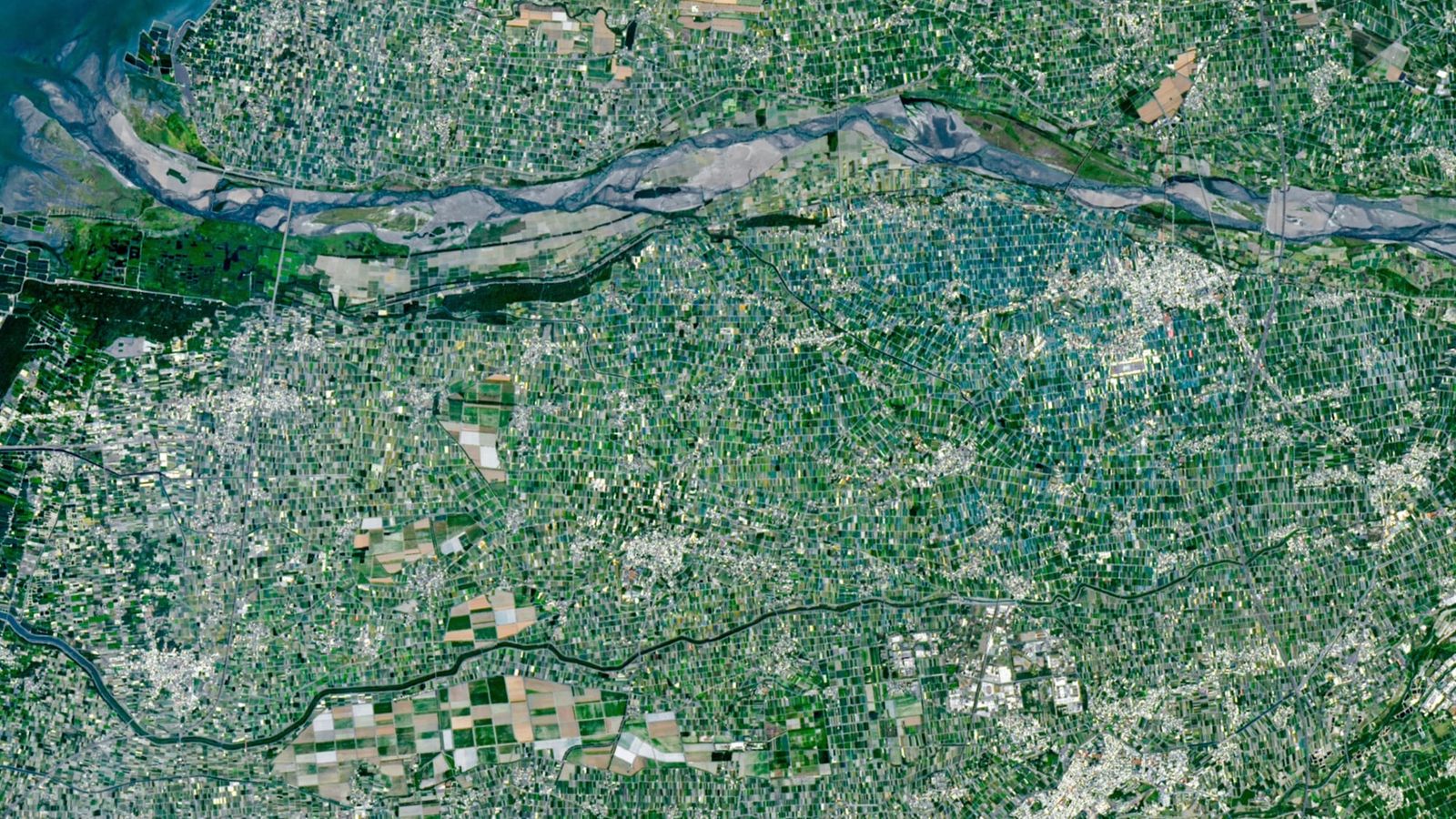
The most luminous anomaly appears around the town of Xiluo, situated directly south of the riverbed.12 In this district, the fields display an intense blue and turquoise tint rather than vegetative shades of green.12 This visual signature is produced by thousands of synthetic shade nets erected over delicate commercial crops.21 Local growers deploy the protective plastic netting to shield specialty harvests, including leafy vegetables, fruits, and cut flowers, from blistering summer sunlight, invasive insect pests, and violent subtropical monsoon rainfall.21 This bright cyan district contrasts sharply with the deep green plots situated further south and east, where flooded paddy fields produce staple crops of rice.2
A second major structural break occurs near the town of Baozhong in the southwestern quadrant of the image.12 Surrounding Baozhong, the farmland consists of much larger, pale-toned rectangular plots that look noticeably different from the dense grid of micro-farms nearby.12 These fields represent the historical footprint of commercial sugar plantations established during Japanese rule over Taiwan between 1895 and 1945.12
Colonial administrators converted large areas of the Chianan Plain into industrial sugarcane fields, constructing an extensive internal rail network to haul harvested stalks directly to processing mills.12 Following the conclusion of World War II, these large plantations were nationalized and merged into the Taiwan Sugar Corporation.2 Although domestic sugar production has contracted in recent decades and most historical railway lines across the island have been decommissioned, the Taiwan Sugar Corporation continues to cultivate sugarcane on these consolidated parcels.21 Harvested cane is transported along the last active sugar railway line on the island to a surviving refinery located in nearby Huwei.21
What can orbital views teach agricultural planners?
Satellite imagery provides a structural inventory of physical land use, but it cannot measure real-time soil health, aquifer depletion, or the economic stability of individual farming households. Multispectral sensors capture the spectral reflection of canopies, plastic mesh, and bare dirt, yet they do not record fertilizer run-off rates or labour availability across smallholder communities. Interpreting land conditions from orbit also depends on assumptions about seasonal crop rotations, because a plot that appears barren or pale during spring planting can transform into dense green foliage several weeks later.
Even with those operational limits, high-resolution Earth observations offer valuable insight into how densely populated coastal regions adapt to severe geographical barriers. As warming climates shift regional precipitation cycles and alter monsoon intensity across East Asia, protective structures such as the shade nets of Xiluo illustrate the technical adjustments that smallholders use to insulate vulnerable harvests. The satellite view captures an ongoing compromise between historical tenure legislation, modern micro-farming, and the spatial limits of an island population working within a narrow strip of arable soil.
The record
30 sentences trace to 2 sources.
-
1
HB
Harry Baker Document · livescience.com · 13 Oct 2026 Multicolored 'mosaic' of mini farms surrounds Taiwan's largest river — Earth from space See the source
-
2
NS
NASA Science Official record · science.nasa.gov · 24 Apr 2026 An Agricultural Mosaic in Taiwan - NASA Science See the source