Subterranean thaw triggers massive permafrost detachment slides across northern valleys
Deep ground heating spurred by decades-old wildfires can abruptly destabilize Arctic slopes, sending house-sized slabs of frozen earth into river systems as northern climates warm.
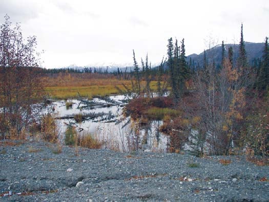
Across the northern reaches of North America, frozen ground has historically acted as an immovable geological anchor. In subarctic valleys where temperatures stay low enough year-round, soil, gravel, and ice fuse into permafrost, holding steep hillsides together for millennia. When warming temperatures melt this frozen terrain, it typically collapses in a slow, muddy slump from the surface downward.12 Slopes soften, topsoil liquifies into a slurry, and mud trickles gradually down the grade over multiple summers. For generations, this gradual top-down thaw defined how researchers and northern residents understood slope failure in permafrost terrain.
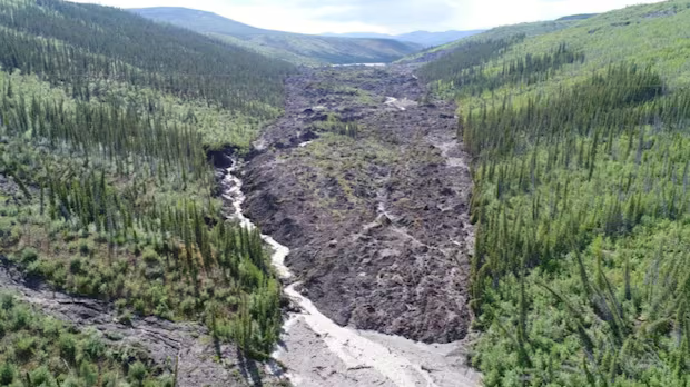
That predictable pattern has recently been broken by sudden, colossal structural collapses. Instead of surface mud trickling downhill, intact mountainsides have fractured from deep within the ground, dislodging towering blocks of frozen sediment as large as two-story residential homes. These deep failures, known as permafrost detachment slides, tear open valley slopes in days rather than decades, damming mountain rivers, creating unexpected lakes, and smothering downstream aquatic systems beneath millions of tons of displaced debris.12
The transformation matters because permafrost underpins thousands of miles of northern infrastructure, river basins, and traditional travel routes across Canada and Alaska.1 When an entire hillside shears off at depth, the consequences for the surrounding landscape are immediate and severe. Waterways that local ecosystems rely upon can be cut off overnight behind unstable natural dams. As rising temperatures alter northern wildfire frequency, the underlying conditions that make slopes vulnerable to sudden detachment are expanding across territories once thought immune to rapid collapse.1
How can frozen ground fail from the bottom up?
A permafrost detachment slide requires a specific, delayed sequence of environmental events to destabilize a mountain slope.2 The process begins decades before any visible movement on the surface, often triggered by a severe wildfire that sweeps through subarctic forest and tundra.12 The fire burns away the thick, protective layer of moss, peat, and organic vegetation that normally insulates the frozen earth from summer heat.2 Without this insulating blanket, summer air temperatures and seasonal rainfall push ambient warmth into the mineral soil underneath.2
Over subsequent summers, this thermal disturbance does not simply remain near the surface. Surface drying and structural settling create subtle vertical fissures along the upper portions of the slope.1 These cracks open conduits for surface moisture and seasonal heat to bypass the upper frozen zone and penetrate progressively deeper into the hillside.1 The downward wave of thermal energy moves slowly through the earth, advancing over the course of 15 to 20 years.2
When this descending pulse of heat finally reaches the vulnerable boundary at the bottom of the permafrost layer, roughly 20 meters beneath the surface, it thaws the ice anchoring the slope to the underlying bedrock.12 The melting ice at the base generates pressurized water, creating a slick, saturated slip plane. The massive weight of the overlying, fully frozen slab of earth shears away along this lubricated base. Rather than dissolving into mud, the frozen block slides downhill in a rapid, catastrophic failure.1
What did field surveys in the Mackenzie River basin reveal?
Researchers investigating two massive slope collapses in the Sahtu and Dehcho regions of Canada's Northwest Territories discovered that this subterranean failure mechanism had reshaped two major river valleys.2 Lead author Joseph Young, who conducted the study during his doctoral degree at the University of Alberta alongside co-author Steve Kokelj of the Northwest Territories Geological Survey, documented the collapses in a study published in Geophysical Research Letters.12 The paper reports that the slides represent an unprecedented type of ground failure in the region, with no record of comparable events occurring there over the past 10,000 years.1
The first major event occurred along the Johnson River in August 2017, dislodging approximately 18 million cubic meters of soil and frozen rock, an amount sufficient to fill about 7,200 Olympic-sized swimming pools.12 The collapse ripped a continuous scar nearly 3.2 kilometers long into the hillside and deposited a colossal dam across the river channel.12 Pilot Eric McLeod, who regularly flew over the Johnson River Valley between 2017 and 2021, observed from the air that the displaced earth had completely blocked the river, creating a brand-new lake behind the debris.2 McLeod landed at the site shortly after the collapse and noted that displaced chunks of earth stood as large as houses, with one intact block measuring approximately 20 feet thick.2
A second major collapse struck the Redstone River Valley in August 2018, moving almost 4.5 million cubic meters of earth across a debris field stretching 1.2 kilometers down the valley slope.12 Field observations led by Young identified frozen blocks within the debris pile measuring up to 10 meters tall, matching the height of a two-story building.1 To determine how deep the frozen layer extended before failing, the research team ran electrical currents through the ground, measuring subsurface electrical resistivity to map the depth and boundary of the permafrost.1
By combining geophysical measurements, satellite imagery, and long-term climate records, the researchers determined that the permafrost in the area had warmed by roughly 0.3 degrees Celsius per decade since monitoring began in 1980.1 However, regional atmospheric warming alone could not account for the abrupt collapses. Historical fire records revealed that both valleys had experienced severe wildfires in 1995.12 The 20-year lag between the 1995 fires and the massive collapses in 2017 and 2018 matched the exact duration required for surface heat to conduct 20 meters downward to the base of the permafrost.12
What can these valley collapses tell researchers about future northern terrain?
The findings provide an empirical explanation of a new geological hazard, but they do not serve as a precise forecasting tool for every hillside in the subarctic. The data describe a mechanical response observed in relatively thin permafrost layers between 20 and 40 meters thick, where a lubricated basal plane can develop.1 Regions underlain by continuous permafrost hundreds of meters deep operate under different thermal dynamics and are unlikely to experience basal failure from modern wildfire burns.
The study also relies on retrospective climate and burn data rather than continuous subsurface thermal instrumentation installed prior to the failures. While the researchers mapped more than 150 similar, smaller detachment features across the surrounding territory, each typically displacing over 1 million cubic meters of material, the exact timing of future failures depends on local soil moisture, slope angle, and bedrock geometry that vary valley by valley.1
Despite these analytical limits, the research highlights a significant delayed consequence of northern environmental change. As wildfires grow more frequent and intense across Canada and Alaska, millions of hectares of forested permafrost slopes are losing their insulating vegetative cover.1 Because the heat takes approximately two decades to penetrate deep into the ground, landscapes burned during recent severe fire seasons may already harbor subterranean thaw fronts moving inexorably toward basal slip planes. While remote locations have so far spared human infrastructure from direct hits, the abrupt damming of waterways and sudden release of sediment downstream indicate that northern landscapes can cross critical stability thresholds decades after the initial disturbance.1
What happens next as the subarctic landscape continues to adjust?
The discovery of deep-seated detachment slides shifts the focus of permafrost monitoring from immediate post-fire erosion to multi-decade surveillance. Young and Kokelj noted that permafrost detachment slides do not happen entirely without warning, pointing out that slopes begin showing creeping downslope movement and expanding tension fractures years before total failure occurs.2 Geologists are now assessing whether satellite radar interferometry can detect these subtle surface shifts to provide early warning of impending valley collapses.
At the same time, regional water managers and aquatic biologists are evaluating the long-term ecological consequences of river damming. The sudden impoundment of subarctic rivers alters water temperatures, traps migrating fish species, and triggers sudden sediment pulses that degrade downstream water quality for seasons afterward. As northern research teams track the slow creep of heat through subarctic slopes, the silent progression of 20-year-old burn scars has emerged as one of the most consequential geological shifts in the warming North.
The record
31 sentences trace to 2 sources.
-
1
SP
Stephanie Pappas Document · livescience.com · 26 Oct 2026 'A potential glimpse into the future': Climate change has triggered 'permafrost landslides' with house-size blocks of ice in Canada See the source
-
2
C
CBC Third-party reporting · cbc.ca · 12 Oct 2026 Study says 'bottom-up' permafrost thaw led to two major N.W.T. landslides | CBC News See the source